Underwater robot sheds new light on Antarctic sea ice
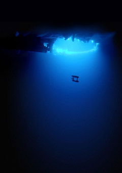
The first detailed, high-resolution 3-D maps of Antarctic sea ice have been developed using an underwater robot. Scientists from the UK, USA and Australia say the new technology provides accurate ice thickness measurements from areas that were previously too difficult to access.
The results, published this week in the journal Nature Geoscience (Monday 24 November 2014), step up the pace of research in the polar regions aimed at understanding the dramatic sea ice changes in the context of climate change.
Scientists use a range of technologies and techniques to measure sea ice thickness. Satellite observations can measure large-scale thickness from space, but interpreting the data accurately can be difficult due to snow cover on the ice. Measurements made on the sea ice by drilling holes, together with visual observations from ships are critical for building a more complete picture, but difficulties in getting access to thicker areas of sea ice leaves gaps in the data. Now, with the Autonomous Underwater Vehicle (AUV) known as SeaBED, scientists have an invaluable new tool to fill this gap.
read more… – British Antarctic Survey (BAS)


