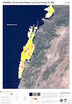
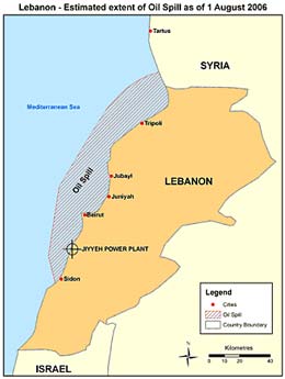
First Satellite Imagery Shows that Oil Spill Reaches Syrian Coastline. Access is Needed for Immediate Clean-up 2 August 2006, Nairobi/Athens — The oil spill that has already polluted over 80 kilometres of the Lebanese coastline has reached the Syrian coastline and is spreading further north. Satellite imagery from the Joint Research Centre (JRC) of the European Commission (EC) now shows that the oil slick has entered Syrian waters and has already contaminated approximately 10 kilometres of coastline north of the borders between Syria and Lebanon.
“It is nearly three weeks since the bombing of the power plant and the initial satellite imagery unfortunately confirms that the oil spill is of a significant magnitude and spreading. A coordinated response must urgently be allowed to proceed, so that we can limit the immediate environmental damage as well as the longer terms implications for the economy and the Lebanese people”, said United Nations Under-Secretary-General Achim Steiner, the Executive Director of UNEP, speaking from Nairobi.
“Now it has become even more vital to take immediate action. In addition to the humanitarian circumstances, an environmental catastrophe is threatening the Mediterranean region”, said Mr Paul Mifsud, the Coordinator of the United Nations Environment Programme – Mediterranean Action Plan (UNEP-MAP). “Hostilities must cease to guarantee immediate safe access to the affected area”.
In a letter addressed to UNEP-MAP in Athens today, the Syrian Minister of Local Administration and Environment Mr Helal Al-Atrash asked UNEP-MAP “to send professional companies to control the spilled oil on the shoreline and territorial waters […] and to send experts for the assessment of environmental degradation costs”.
The Regional Marine Pollution Emergency Response Centre for the Mediterranean Sea (REMPEC), one of UNEP-MAP's Regional Activities Centres, has requested the Government of Cyprus to run a spill forecast model, called MEDSLIK. Developed specifically for the eastern Mediterranean, it can provide indication whether or not a part of the oil could reach other Mediterranean coastal States, north of Lebanon.
The analysis is conducted by the Oceanographic Centre of Cyprus, and initial results show that 80% of the oil remains on and off the Lebanese shoreline, while only less than 20% evaporated.
Following a request of support to the Contracting Parties to the Barcelona Convention, REMPEC has already received replies from nine entities offering assistance: Algeria, Cyprus, the European Commission, France, Greece, Italy, Malta, Spain and Syria.
Meanwhile, REMPEC officially placed its Mediterranean Assistance Unit (MAU) on stand-by and is preparing for the mission of a senior expert to the affected area, as soon as security clearance is received.
02.08.2006, United Nations Environment Programme
www.unep.org
")


